Drone LiDAR is changing the way engineers and surveyors capture terrain and infrastructure data. With drone LiDAR mapping, a LiDAR sensor mounted on a UAV collects millions of laser points per second, creating highly detailed 3D models. These survey-grade datasets give civil engineers and survey teams the accuracy they need for design, planning, and construction workflows—faster and often more cost-effectively than traditional ground methods.
Why Drone LiDAR Mapping Matters for Engineers and Surveyors
For civil engineers, surveyors, and geospatial professionals, drone LiDAR offers a faster, safer, and often more cost-effective way to map large or difficult terrain compared to traditional conventional ground methods or photogrammetry alone. In some cases, it can even be more cost effective than manned aviation.
In this guide, we’ll explore:
- What drone LiDAR mapping is and how it works
- The equipment and workflow involved
- Advantages over other mapping methods
- Real-world use cases
- Key considerations for accuracy and deliverables
What Is Drone LiDAR Mapping?
LiDAR (Light Detection and Ranging) is a remote sensing method that uses laser pulses to measure distances between the sensor and the ground or objects. When integrated with high-precision GNSS (Global Navigation Satellite System) and an IMU (Inertial Measurement Unit), LiDAR can create dense, accurate 3D point clouds.
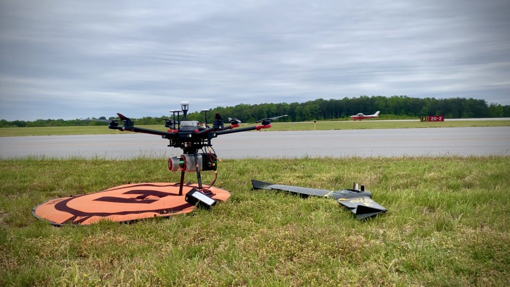
In drone LiDAR mapping, these sensors are mounted to UAV platforms, typically multi-rotors or fixed-wing drones to scan terrain from the air. The combination of aerial mobility and high-frequency laser scanning allows for rapid coverage of large areas and the ability to penetrate through vegetation to model bare-earth surfaces.
Further reading: USGS LiDAR 101 Overview
How Drone LiDAR Mapping Works
Key Components
- LiDAR Sensor – Emits laser pulses and measures their return time to calculate distances.
- Example: DJI L1/L2, RESEPI Hesai, RIEGL VUX-1LR, Velodyne Puck Lite
- GNSS Receiver – Tracks the drone’s position at 1 Hz.
- IMU – Measures orientation and movement to correct the LiDAR data.
- Onboard Computer / Data Logger – Records raw LiDAR and navigation data.
- Post-Processing Software – Merges sensor data, applies GNSS/IMU corrections via PPK, and generates point clouds.
Resource: NOAA LiDAR Basics
The Mapping Workflow
- Flight Planning – Determine altitude, speed, swath width, & overlap. Not talking about airspace/safety in this post.
- Data Collection – Fly the planned mission, ensuring GNSS lock and system health.
- Trajectory Processing – Use GNSS base station or network corrections (RTK/PPK) to improve positional accuracy.
- LiDAR Data Calibration – Merge trajectory data with LiDAR returns, correcting for sensor orientation and timing.
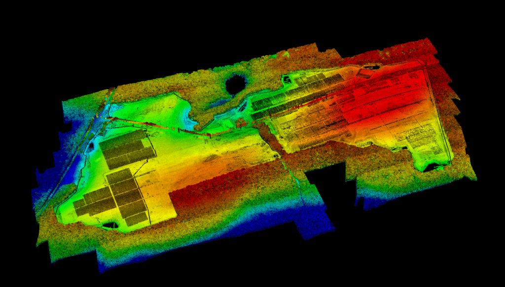
- Point Cloud Classification – Assign points to categories (ground, vegetation, buildings).
- Surface Modeling – Create DSMs, DTMs, or contour lines from the classified data.
Advantages of Drone LiDAR Mapping
1. Penetrates Vegetation
Unlike photogrammetry, LiDAR can capture ground points beneath tree canopies, making it ideal for forestry, floodplain mapping, and right-of-way surveys.
2. High Accuracy
With PPK or SBET (Smoothed Best Estimate of Trajectory) processing, horizontal and vertical accuracy can reach survey-grade levels, often ±3 cm or better.
Learn more: ASPRS Accuracy Standards for Digital Geospatial Data
3. Rapid Data Collection
Cover hundreds of acres in a single flight, reducing field time significantly compared to terrestrial methods.
4. Versatility
Can be deployed over rugged terrain, waterways, and areas unsafe for ground crews.
Drone LiDAR Mapping vs Photogrammetry
| Feature | LiDAR | Photogrammetry |
|---|---|---|
| Vegetation Penetration | ✅ | ❌ |
| Lighting Requirement | Works day or night | Needs good light |
| Data Volume | Large, high density | Moderate |
| Accuracy Potential | High. Uses PPK | High with RTK/PPK can be terrain dependent especially with vegetation |
For a deep dive on the differences, see Pix4D: LiDAR vs Photogrammetry.
Real-World Use Cases
- Civil Engineering Design – Generating topographic surfaces and base maps for projects.
- Environmental Studies – Monitoring erosion, floodplains, and wetlands.
- Forestry Management – Measuring canopy height, biomass, and forest health.
- Construction Monitoring – Progress mapping and volumetric calculations for earthworks.
- Corridor Mapping – Railways, powerlines, and pipelines.
Note: For my survey-based applications, LiDAR is for the limited purpose of topography. In general, I do not generate 2D planimetric improvements from the LiDAR data. Especially under the canopy. LiDAR is great for getting to ground through dense canopy, but it is not detailed enough under the canopy to see edge of pavement for a sidewalk through the woods or human made improvements with sufficient detail for drafting.
Example project: FHWA LiDAR Applications in Transportation
Accuracy Considerations
Achieving survey-grade accuracy with drone LiDAR mapping requires:
- Proper calibration of the LiDAR system
- Accurate GNSS data (RTK, PPK, or NTRIP corrections)
- Use of a well-placed GNSS base station or network service
- Careful flight planning to maintain consistent point density
- Post-processing with trajectory refinement (SBET generation)
Cost Factors
Project cost depends on:
- Project size and complexity
- Required accuracy
- Terrain and vegetation
- Deliverable formats and classification needs
Reference: Commercial UAV News – LiDAR Pricing Trends
When to Use Drone LiDAR Mapping
Choose LiDAR when:
- Vegetation obstructs photogrammetric bare earth ground capture
- Client request it
Conclusion
Drone LiDAR mapping has become a cornerstone technology for engineers, surveyors, and geospatial professionals who demand accurate, fast, and reliable data. While it requires specialized equipment and expertise, its advantages ,particularly in challenging environments, make it indispensable for many projects.
By understanding the workflow, benefits, and considerations, you can decide when drone LiDAR is the right tool for your project and ensure you get the best possible results.
Drone LiDAR Mapping FAQ
What is Drone LiDAR Mapping?
Drone LiDAR mapping uses laser scanning sensors mounted on UAVs to capture millions of data points that represent the earth’s surface and features in 3D. Unlike photogrammetry, LiDAR can penetrate vegetation to capture bare-earth terrain models, making it ideal for topographic surveys, corridor mapping, and engineering design.
How accurate is Drone LiDAR Mapping?
With high-quality sensors like the RiEGL VUX-1LR I use, properly flown missions, and post-processing with PPK/trajectory corrections, vertical accuracy can reach 3–5 cm RMSE. However, accuracy depends on flight altitude, ground control, and processing methods.
What industries use Drone LiDAR Mapping?
Civil engineering, transportation, utilities, forestry, and renewable energy projects (solar/wind) rely on drone LiDAR for topographic surveys, as-built verification, vegetation analysis, and infrastructure inspection.
Do I still need ground control if I use RTK or PPK?
Yes. Even with RTK or PPK, well-placed ground control points (GCPs) provide an independent accuracy check and tie datasets into your project coordinate system. (Link internally to your planned blog: “Why We Still Use Ground Control with RTK Drone Mapping”).
What’s the difference between LiDAR and Photogrammetry?
I like to say one is active and one is passive. Photogrammetry builds 3D models from overlapping images which is a passive method of interpolating data, while LiDAR actively/directly measures distance with laser pulses. LiDAR performs better in dense vegetation and delivers higher consistency for elevation models. Photogrammetry is often more cost-effective for small, open areas.
How do I choose between RTK and PPK for Drone LiDAR?
RTK provides live corrections but requires reliable connectivity via a local base or network NRTIP base. PPK applies corrections afterward using base station RINEX data logged, often delivering higher accuracy and reliability. Many surveyors prefer PPK because it avoids issues with dropped corrections. (Upcoming post: “The Role of PPK and SBET in Drone LiDAR Mapping”).
Can Drone LiDAR penetrate vegetation?
Yes. LiDAR pulses can reach the ground through gaps in tree canopy, producing bare-earth Digital Terrain Models (DTMs). Photogrammetry cannot do this reliably, making LiDAR the go-to for wooded projects.
What deliverables can I expect from a Drone LiDAR survey?
Typical deliverables include:
Planimetric linework (roads, buildings, utilities)
Classified point clouds (.las/.laz)
Digital Terrain Models (DTM)
Digital Surface Models (DSM)
Contours
Orthomosaics (if combined with imagery)
How long does it take to complete a Drone LiDAR project?
That depends on the drone and payload capabilities. We can collect 1,000 acre project in a day, with processing/delivery usually within a week depending on scope and client requirements.
How does Drone LiDAR compare to traditional surveying?
Drone LiDAR reduces field time dramatically. Instead of weeks of boots-on-the-ground topo, drones can cover thousands of acres in a few flights. Traditional surveying is still required for certain features, but LiDAR accelerates projects and improves safety.