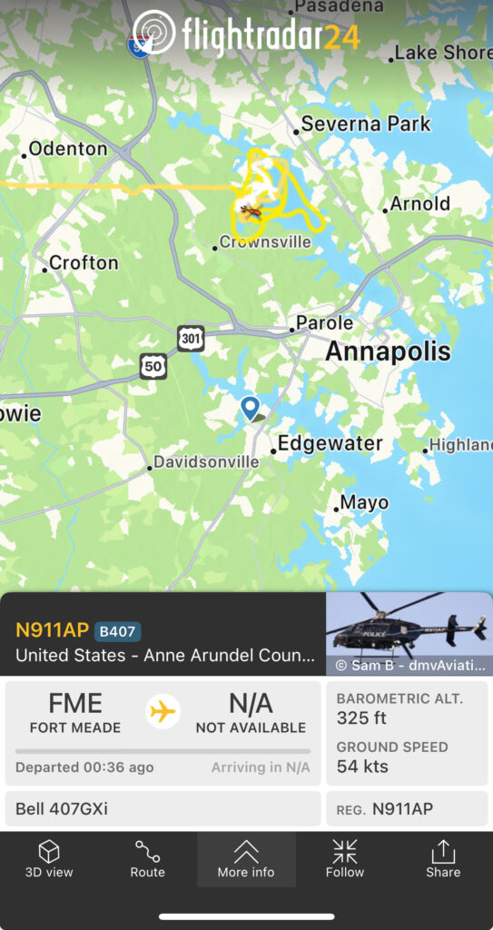
When you fly drones in complex or shared airspace, one of the best ways to build situational awareness is by monitoring nearby manned aircraft. The Flightradar24 app or website is a common tool many of us use to easy to visualize nearby aircraft in real time, but what you see on the screen is only part of the story. Especially the free version. Most aircraft broadcast their barometric altitude based on pressure, not their actual height above ground. As drone pilots, we fly under a 400-foot AGL (Above Ground Level) ceiling, so it is critical to understand how to convert that barometric reading into something meaningful and safe.
Why I Wrote This Post
In this post, I want to walk through how I use Flightradar24 during missions, how to convert the barometric altitude from ADS-B to actual AGL (Above Ground Level), and share some personal takeaways from the recent NTSB hearings into the January 29th mid-air collision near D.C. that killed 67 people. That tragedy hit hard, and it reminded me just how fragmented the National Airspace System still is.
I have also built a free online calculator that lets you plug in the barometric altitude from Flightradar24 data and convert it into meaningful AGL numbers based on your location. It’s linked above, but hold off opening it until you understand the basics.
Understand What Flightradar24 Shows You
Flightradar24 collects most of its aircraft data from ADS-B transmissions. These broadcasts typically include:
- Aircraft type and identifier
- Latitude and longitude
- Ground speed and heading
- Barometric altitude
That last item is especially important. Most manned aircraft report their altitude using barometric pressure rather than GPS. This is intentional because barometric altitude provides a consistent frame of reference across all aircraft flying in the same region. It is based on standard atmospheric pressure and does not rely on geoid models or require local offsets the way GPS-based altitude often does.
Using barometric altitude ensures all aircraft are referencing the same altitude layer, which is crucial for separation and air traffic coordination. However, it does not account for elevation changes on the ground. For example, an aircraft flying at a barometric altitude of 1,100 feet may be only a few hundred feet above ground level in a valley or more than 1,500 feet AGL if flying over higher terrain.
This is why drone pilots need to convert barometric altitude to AGL before making any decisions based on what they see in Flightradar24.
Convert Barometric Altitude to AGL
To understand how close a manned aircraft is to your airspace, you need to subtract the elevation of the ground below it from the barometric altitude reported.
Here is a simplified formula:
AGL = Barometric Altitude – Ground Elevation
To use this method in practice, you need three things:
- The barometric altitude from Flightradar24
- The altimeter pressure for the nearest airport.
- The ground elevation at your location
The easiest way to get ground elevation is to pull data from a digital elevation model or a tool like USGS’s Elevation Point Query. However, that is time consuming in the field. That is why I built a free calculator that helps automates this.
The calculator solves that by:
- Fetching the local altimeter setting via METAR using your nearest airport code.
- Auto-detecting your ground elevation using GPS and a public elevation API.
- Applying a correction to convert ADS-B barometric altitude into a true altitude above Mean Sea Level (MSL).
- Calculating AGL by subtracting your elevation from the corrected true altitude.
The result: an estimated AGL for any aircraft at your location, helping drone operators stay situationally aware and within FAA compliance boundaries .Just enter your nearest IACO airport code, hit fetch on the METAR button, the altimeter setting is pulled in, enter the ADS-B altitude, then hit auto-detect for your ground elevation. Once you have all the fields populated hit calculate
What the NTSB Crash Investigation Taught Me
I watched many minutes of the NTSB hearings into the January 29th collision near D.C. and I came away deeply unsettled. The NTSB confirmed the Black Hawk helicopter was flying at 300 feet, 100 feet higher than the 200-foot limit corridor when it collided with an American Airlines regional jet on approach. The crash killed all 67 people on both aircraft.
One thing I did not realize before the hearing is that most aircraft do not have ADS-B In, meaning they can broadcast their location but cannot see where other aircraft are. Airliners rely on TCAS, but many other general aviation aircraft often do not have it. That makes conflict avoidance a one-sided system.
What surprised me most is how fragmented the National Airspace System still is, even though we have had the technology to solve these issues for years. The FAA and military had been warned about the route conflicts around Reagan airport. Controllers formally requested that the FAA relocate helicopter flight paths, but those warnings were not acted upon.
Final Thoughts and Takeaways
Your Role as a Part 107 Pilot
As a Part 107 pilot, I take full responsibility for my aircraft during every flight. I routinely operate in areas with manned traffic, and I never assume that “see and avoid” is enough. Flightradar24 is one of the tools I rely on to enhance situational awareness.
It’s important to remember that as a Remote Pilot in Command under Part 107, we are the lowest tier in the aviation hierarchy. The burden is on us to detect and avoid manned aircraft, to stay clear of their paths, and to maintain visual line of sight at all times. Remote ID is not visible to crewed aircraft. ADS-B signals are not received by most general aviation pilots. And yet, we’re still held accountable for avoiding conflicts — even when other aircraft may not know we’re there.
I live and fly in the Hampton Roads, Virginia area, which I believe is one of the most complex regions in the National Airspace System. Northern Virginia edges it out for the top spot, but Hampton Roads combines Class C and D airspace, high-volume commercial and general aviation, military jets, helicopters, and even parachuters. On top of that, much of Virginia is crisscrossed with military training routes that don’t always show up on tools like Flightradar24. You need to plan carefully, fly defensively, and stay sharp.
The Bigger Picture: AAM and Airspace Modernization
All of this is unfolding as the FAA, NASA, and industry partners work to advance the integration of electric vertical takeoff and landing aircraft. Advanced Air Mobility (AAM) aims to bring new air traffic — from urban air taxis to regional eVTOL cargo flights — into our skies. It’s an ambitious goal, and it will require big upgrades to airspace management, regulations, and communication systems.
There is a lot of modernization and system integration that still needs to happen. And it needs to happen fast.
Until then, tools like Flightradar24 and our AGL conversion calculator can help keep your situational awareness sharp. Use them well. Fly smart. Stay safe.