Drone mapping isn’t just pushing a button and waiting for a pretty orthomosaic — especially in civil engineering. Whether it’s topographic surveys, volume calcs, or as-builts, the demands are real, and the margin for error is slim. I’ve worked alongside civil engineering teams for years, collecting drone data that feeds directly into site design, grading, and stormwater modeling.
This post walks through what real-world drone mapping looks like for AEC teams — from the gear to the workflows — and how we keep it licensed, accurate, and field-ready.
Deliverables That Actually Get Used
Civil engineers don’t need eye candy — they need data they can measure and build from. That’s why our drone workflows are built to feed directly into CAD and GIS.
We routinely generate:
- Survey-grade orthomosaics (2–3 cm GSD)
- LiDAR-derived topographic surfaces
- Planimetric data from Orthomosaic
- Volume and stockpile calcs
- Roadway corridor alignment models
- As-built point clouds
The key? Every deliverable is QA’d and finalized by our team.
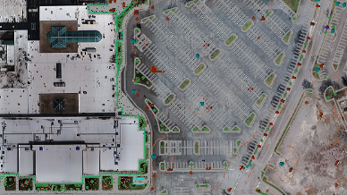
Planimetric data from Ortho
What It Takes to Get the Right Data
The idea that you can show up and launch a drone doesn’t hold up on civil jobsites. Here’s a glimpse into our typical pre-flight planning checklist:
- Preliminary flight plan and ground control layout at time of quoting project
- Airspace clearance (especially if near controlled zones or sensitive facilities)
- Ground control layout and flight plan finalized (surveyed GCPs or PPK/RTK workflow validation)
- Risk mitigation: wind, obstructions, crew awareness
- On site safety orientations (often required)
- Don’t forget all the required PPE!
- Set & locate control
- Adapt, overcome, & fly!
I use tools like Global Mapper, QGroundControl, Pilot 2, Pix4Dmapper – all backed by solid workflows.
Post-Processing is the Other Half of the Job
No matter how good the flight went, the data’s only useful if it’s clean, aligned, and geospatially accurate.
For photogrammetry, we run our datasets through Pix4Dmapper, optimized for flights flown with RTK-enabled capture. We’ve fine-tuned our processing templates to ensure tight image calibration, high-density point clouds, and orthos that align with surveyed checkpoints. While RTK minimizes the need for GCPs, we still use more than required to verify positional accuracy on every project to meet engineering and survey-grade requirements.
For LiDAR, we use PPK/IMU corrections to make an SBET, boresighting, and sometimes StripAlign to nail down strip integrity. I have some strong opinions about IMUs and the need for Strip Alignment (another time).
Once that’s done, we classify the point cloud, build breaklines IF needed (another post another time), and pass the final deliverables to our Survey Technicians for use.
We also use more ground control than most, even when flying RTK -not because we have to, but because it helps us sleep well at night. This industry isn’t very forgiving when things go sideways, and it has a memory like an elephant. Precision matters, and we’ve learned it’s better to double/triple-check than to explain later.
Partnering with Engineers – Not Selling to Them
I’m not here to sell drones or push a platform. I’m here to support your engineering work with data that meets your standards and deadlines – every time.
All work is performed through a licensed surveying firm and compliant with FAA Part 107 regulations. I handle the mission planning, collection, and post-processing to make sure what we hand off is survey-grade, compliant, and actionable.
If you’re looking for drone LiDAR, photogrammetry, or mobile mapping support – let’s talk scope.